Launch could have been a set for hang glider porn; cummies filled the sky, birds were climbing, and a soar-able breeze was blowing straight into launch. We quickly rigged and danced off launch. (Thanks for the wire-assist Dan.) I quickly climbed above the ridge line and never worried about sinking out for the rest of the day.
Jeff, PK, and I talked about flying north along the valley together even though we didn't have a driver. However that plan started falling apart right after launch when I discovered Jeff's radio was completely hosed. Furthermore, PK had one of those days where he was always in the "wrong spot at the wrong time"!
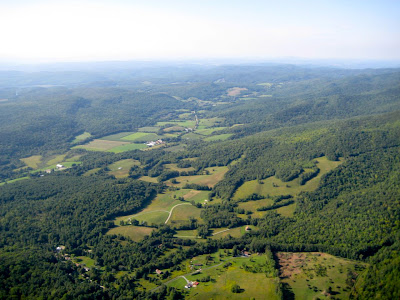
Valley to the northwest
John and I found a nice climb to cloud base (1100m; 3800 feet) to the west but unfortunately PK was low on the ridge near launch. John and I then flew upwind, finding climbs under every cloud. John continued on to circle Bird's Eye (a peak to the south) while I returned to hook up with PK. I found another climb to base on the way back while PK dove across the valley to hook up with John and ended up low once again. Dang. I played at cloud base to the west for awhile and then flew across the next valley to the northeast and waited on PK or Jeff at base (1250m; 4100 feet). I almost took off but since I didn't have a retrieve and two pilots were hoping to fly with me, I flew back upwind to the ridge.
Launch ridge and bowl
Peaks to the south
The increasing haze and drying clouds confirmed that warmer, humid, and more stable air was moving in. However the increasing wind meant the ridge and valley were still quite soar-able. Once the urge to leave was calmed, I played around with different climbing and gliding techniques.
Bo
Valley to the east (West Rutland and Rutland)
Near the end of the flight PK and I pushed 7 km (4 miles) upwind only losing 100m (300 feet) on the trip. After exhausting our altitude we blew back and started soaring the small bump in front of the LZ. PK had enough for the day and asked me to give him a head start for the LZ. I ran to the base of the ridge and benched up to Jeff's altitude. I wanted to get some closeup photos of Jeff as we headed out to land but the air just wasn't smooth enough any more since the peaks to the south were throwing off turbulence in the stronger wind. It also meant the approach to the LZ was probably getting exciting.
LZ is mowed strip on "top" of pyramid shaped corn field.
PK confirmed my concern when he described his approach and then Jeff's. The LZ sits downwind of a hill and can be rowdy before you round-out near the surface. Although the LZ is large, most of the field hasn't been mowed this year since it is too wet. This means the best place to land is a small mowed section along a triangle-shaped corn field. The mowed area is large enough but in my glider you have to cross a small tree line low if you want to land there. PK managed to land on the strip OK and that was my plan as well until I got dropped twice during my approach. I didn't want that to happen again and not have enough altitude to clear the tree line. So I cut my approach short, came in high over the tree line, and landed in the tall grass. I made the safe decision but wonder if there is another approach that is as safe and doesn't require walking through tall soggy grass.
Dan graciously rode up with Bob to get my truck while Jeff and I quickly packed to beat the setting sun. Amy and Jeff had their longest flights to date; Amy with 2+ hours and Jeff with 4+. Everyone seemed to enjoy the day. Although I initially wanted to go XC, I still had tons of fun trying to optimize my climb and glide performance, exploring the edges of my glider's flight envelop, and just playing around in the air on a late summer's day.
Flights: 1, Duration: 4:42


